Sunday, September 24, 2006

Day 8 - "....San Bernadino..."

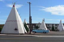
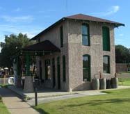
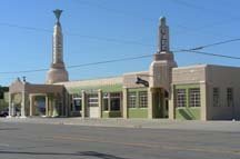
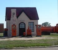
The last leg of our journey was probably the most different from those who traveled down Route 66 in its heyday. We started in Barstow and left the desert behind us. In San Bernadino we found the secon
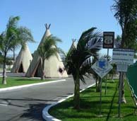
d wigwam motel along the road. This was a much classier version (and looked absolutely immaculate) than the first. But both were charming (Tommy wasn't interested in sleeping in a teepee, however).

Once we hit San Bernadino, it was pretty much solid city/suburb for the rest of the journey. The last 75 miles or so were the probably the longest of the trip. We passed lots and lots of LA suburbs: Rancho Cucamonga, Pasadena, that sort of thing. Driving into LA on a beautiful Saturday afternoon was probably not the best time to hit the city. The last miles were stop-and-go and took us probably 3 hours to finish.

We final
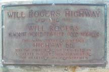
ly arrived in Santa Monica and met up with masses of people shopping and hanging around the beach. Route 66 officially ends in Santa Monica at Ocean Boulevard -- basically the Pacific Ocean. We finally found a parking place and scrambled through the crowds to the visitor's center and the official placque naming Route 66 "Will Rogers Highway." It's difficult to read and unfortunately, I would've loved to have had a "Route 66 Ends" to match it's cousin in Chicago. Ah, well.

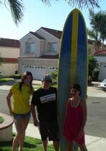
Today (actually Day 9) we spent the day in the LA area. It was Tommy's wish to try s
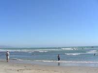
urfing once while we were here. Cousin Mark and his daughters were kind enough to help out. They all love surfing and live quite close to the beach. We visited two beaches, Seal Beach, and Doheny (near Laguna Beach). Tom did great -- he worked hard on it and was able to stand up a few times. Great for his first day! Unfortunately Doheny Beach has lots of rocks on the bottom and his feet are pretty cut up -- surfin' scars to show the friends at home!

Tomorrow we finish up a bit more sightseeing then it's time to start for home -- the fast way this time...

Bob, Heather, Tommy & Winston

Saturday, September 23, 2006

Day 7 - "...Flagstaff, Arizona, Don't Forget Winona, Kingman, Barstow...."

I promised photos of La Posada so here they are:
The photo on the top right is of a gorgeous large room where Bob and Tommy played chess Thursday night. The hotel was really lovely -- a nice "splurge" (although not all that expensive -- we just got a suite so it was a bit more) on an otherwise shoestring-budget trip. I would highly recommend it.

As you can tell from the headline, we blasted through several lines of Bobby Troupe's lyrics. Lots of towns from Winslow to Barstow. We drove through two different areas today that were called the most difficult by two different guidebooks. Personally, I found the first more difficult... a ascent and descent along the mountains on the way to Needles, California. The road was filled with twists and hairpin turns and no shoulder -- just a plunge down the mountain... Bob kept wanting to stop and take photos. He took a few but they don't show the depth well.

The second "most difficult" area was the Mojave Desert. In a car with air conditioning, it's nothing compared to what it must've been like in the 30s and 40s. The desert is a ruggedly beautiful place. But it must've been scary for those travelers in the early 20th century.

We got to Needles in the late afternoon and decided it was too early to stop for the day. We briefly considered camping at Essex (in the desert) but ended up deciding to push on to Barstow.

Thursday, September 21, 2006

Day 6 - "...Gallup, New Mexico...."

Albuquerque is a beautiful city, nestled in the mountains. We followed Route 66 this morning through Albuquerque's Old Town, then headed off west.

Shortly after you leave Albuquerque you travel through several Indian reservations. Old Laguna, a Pueblo reservation, is home to St. Joseph's church (1630), pictured here. Route 66 takes you through several Pueblo villages, with soft, square adobe homes that match the landscape around them. Everything here is sage green or a light terracotta. It's so different to my eyes -- beautiful, but rugged and almost fierce. As we drove I wondered how it would be to grow up with this landscape. Would the tree-lined gentle hills of my home seem crowded to someone from here? Artifically green? Too moist?

It's incredible to watch the landscape change as we drive. We've seen flat lands and mountains and everything in between, black dirt and rust-colored dirt and dirt that's almost pink. Lush, end-of-the-summer vegetation and dry stream beds that only see water a short time during the year. Today we moved from the mountains of New Mexico to flatter ranch land (but still southwestern in feel) in Arizona.

Before you leave New Mexico is the continental divide -- 7275 ft. above sea level -- the point where waters on the west of the divide flows to the Pacific Ocean and the east side of the divide flow to the Atlantic. As northerners (and lovers of northern Ontario) we're more familiar with the Arctic/Atlantic watershed -- a point on Highway 11 north of Kirkland Lake, Ontario where the waters divide between the Great Lakes and Atlantic Ocean (to the south) and the Arctic Ocean (to the north).

After you cross into Arizona, much of the driving is on I-40. There are a few loops through small towns, but generally old Route 66 is gone or in such bad shape that's it's undrivable. One of the last loops we took today was through Holbrook, where the famous Wigwam Motel is located.

Our schedule for this trip has been planned partially around our hotel for tonight, La Posada in Winslow, Arizona. We called about 6 weeks ago on a recommendation (thanks, Ray!) and they were booked up all around the end of September. Except the 21st. It ended up working out well -- this was good timing for us to arrive here today -- didn't require much of a stretch to coordinate.

La Posada is an incredible hotel -- the restored landmark of the Santa Fe Railroad, the Harvey Company, and one of my favorite architects, Mary Coulter. Coulter was the designer of the Grand Canyon lodges and the interior of Union Station in Chicago. The hotel was rescued from the wrecking ball in the late '90s and is now being restored. We didn't get any photos today -- so more about La Posada tomorrow....

Wednesday, September 20, 2006


Day 5 - Vega, TX to Albuquerque

Our first stop this morning was to backtrack (ever so slightly) into Vega. There is a charming restored Magnolia gas station in the center of town that we wanted to see in daylight. The two-story station was built before Route 66 -- when Vega was a stop along the Ozark Trail road. So once Route 66 came through town using the same road, the station was already in place to welcome motorists. The second story of the building was used as an apartment for the owners. Is this blog (and trip?) becoming a tour of depression-era gas stations?

Not too far down the road is the midpoint of Route 66. At Adrian, Texas the road stretches 1139 miles in each direction -- to Chicago and to Santa Monica. So we've come half-way! There's a sweet little cafe at the midpoint, but it was too soon after breakfast to want to stop.

Just before the New Mexico border we passed through Glenrio, a ghost town at exit "0" on the Interstate. In the county of Deaf Smith, it paints a spooky picture of what happens when a road is decommissioned.

We passed into New Mexico, down a long stretch of gravel road, and on to Tucumcari (one of the best town names around!). The Blue Swallow Motel is located there -- a Route 66 landmark, known for its exceptional service. The motel is a wonderful combination of pink and aqua, with a snazzy car parked in front. One of the features of the motel is a garage for every room -- look closely -- they're in between each of the rooms.

Out of Tucumcari we encountered an interesting part of the road -- in order to cross the Interstate you must drive through a drainage tunnel. So larger vehicles just can't be on this part of Route 66...

Most of the last stretch of Route 66 before Albuquerque is actually right under the Interstate, so we spent about 60 or 70 miles on I-40. We stopped in Albuquerque for the evening.

Tuesday, September 19, 2006

Day 4 - You'll See Amarillo....

Outside Oklahoma City, we drove through ranch land with rust-colored soil and green valleys. The same rusty-colored road was pretty much untraveled, except for us. Narrow and straight, it wound up and down hills.

I tried to imagine the dust bowl as I drove. It was difficult to imagine dry, brown dust in this land of rusty-red and dark green. The word "Depression" certainly had many meanings, didn't it?

After the beautifully restored drive-in theater yesterday, this one seemed sad. It's up for sale on eBay -- any takers?

One of the stops today was the Route 66 Museum in Clinton, Oklahoma. They had fun exhibits showing different aspects of the Mother Road, especially the length that runs through Oklahoma. I saw photos of the dust bowl -- amazing -- billowing clouds of dust that covered everything. And we learned the connection with Phillips 66 and Route 66 (two company officials were driving down Route 66 just before the introduction of their new gasoline. One remarked to the other, "this new gasoline makes the car go like 60!" The other looked at the road sign and said, "no, more like 66!" And the name was created). And, of course, the shopping was good. We all found little souvenirs. I bought another map (as if I had any more room on my lap -- as we drive I juggle a narrative on the route, several maps, and several guidebooks). Tom got a Pepsi sign. We found pins, and postcards, of course.

Next was our crossing into Texas. Route 66 goes through the Panhandle. Shamrock (I'd love to hear the origin of that name -- I'm sorry, but this town is about as far from anything reminding you of a Shamrock as you can get...) is right inside the Texas border. A highlight here is this monument-to-Art-Deco: the U-Drop Inn. The building now houses the Shamrock Chamber of Commerce. It's gorgeous (in its own wacky Art-Deco style), and beautifully maintained.

We drove through most of the Texas Panhandle. Flat landscapes with scrubby plants. The road pretty much followed I-40 as it had done yesterday. I know it's September, but I'm amazed not to see others driving Old 66 as we are. Every time we stop, we see Route 66 tourists, but we're not seeing them on the road. Are they all driving the Interstate? The very first Phillips 66 station in Texas (McLean) is along the road -- it's tiny and charming.

We made it just past Amarillo before stopping for the night. The Cadillac Ranch -- an outdoor sculpture by three artists -- is just outside Amarillo. We drove a bit more -- right into the the west and the bright sunset -- and stopped at Vega. The New Mexico border is now about 35 miles away, I believe. Because of the bright sunset we couldn't see Vega properly and will backtrack a bit tomorrow morning. There were several wonderful period buildings I'd like to see again...
Day 3 ...Joplin, Missouri... Oklahoma City Is Mighty Pretty...

We started the day in heart of the Ozarks, Springfield, Missouri. The terrain is not that dissimilar to home (the Irish Hills area of Michigan) -- the hills are just higher. As we drove, Missouri turned from a Midwestern state to a Western state. The hills flattened and the surroundings began to have a look of the west to them.

Navigating along Route 66 can be hard work. Constant vigilance is required. There's no sitting and knitting or reading -- you need to keep your eyes on the road and the road signs pretty much all of the time. We're trying to read "Wicked" aloud in the car but seem to only be able to do it in little bits. The road isn't always easy to find -- we backtracked several times today. I long for those wonderful signs back in Illinois that actually directed you along the road.

Tommy is working on a project for school -- recording theaters we see along the way. There were two spectacular -- but very different -- ones along the way today. The 66 Drive-In in Carthage is a beautifully restored drive-in. Further along is the Coleman Theater in Miami, Oklahoma, a Spanish Colonial revival-style theater built in 1929. Both are restored and in use today.

After leaving Missouri, we spent a few minutes in Kansas. The 15 miles of Route 66 that are in Kansas cut across a tiny corner of the state. While in Kansas we drove across (and stopped at) the Marsh Arch bridge. It was built in 1923 to cross Brush Creek near the Kansas/Oklahoma border and is used by an early alignment of Route 66. It used to be nicknamed the Graffiti Bridge because of all the inscriptions left on it by motorists, but is now restored, thanks to the Kansas Historic Route 66 Association.

Wanting to keep on schedule, we pushed through the first part of Oklahoma, driving the last hundreds miles or so in the darkness (it's getting darker, earlier now). So we missed seeing much of what was along the road between Tulsa and Oklahoma City. We stopped at Oklahoma City for the night...

Sunday, September 17, 2006

Day 2 - "It Goes Through St. Louis..."

Yesterday was such a long day we seemed to need an easier one today.

We got up and spent some time repacking the car. Then we backtracked slightly to the famous Ted Drewes Frozen Custard stand. Every Route 66 guide stresses the need to stop there as you drive through St. Louis -- and who are we to ignore them? We all tried their "Concrete" -- a Blizzard-style mix of frozen custard and flavorings that is so thick you can turn it upside down. Yum!

It began raining as we left Ted Drewes and never really stopped all day. We drove through several downpours and lots of sprinkles. And the sky stayed steely gray.

We spent the rest of day following the Mother Road. It is more difficult in Missouri rather than in Illinois. They have Route 66 road signs here too, but they tend to be informational rather than instructive. They really don't tell you where to go, they just confirm that you're in the right place (if, in fact, you are). So when there were turns, we didn't know if we made them correctly until we came upon a sign. And the Missouri signs are much fewer and farther between.

I-44 follows Route 66 pretty closely through Missouri. So much of our driving was on the service road for I-44. It bounced back and forth from the north side to the south side and back. And, as in Illinois, it took us through a number of towns along the way. We passed this old Phillips 66 station with the wonderful roof (left) in Cuba, MO. The years of Route 66 were a time before there was such as thing as a by-pass. It's fun to be a history detective and discover the remnants of another era as you pass them at 30 mph rather than several miles away at 70 mph.

In St. James we stopped and visited two wineries. You have to do a little work along the way, don't you? Missouri is actually the home of the earliest wineries in the US, dating back to 1837. They grow a very interesting grape here called Norton. It's a native grape (like Concord, Niagara, or Catawba) but with a richer flavor than its other native cousins. They're also growing many of the French hybrids we grow back at the winery.

It was interesting to visit the two wineries. We had a nice experience at the first -- a friendly young man poured their wines for us to try and answered our questions pleasantly. The second winery visit was not quite so positive. It's self-service. And you use tiny plastic cups to taste. Too small to aerate the wine well. And pretty nasty to drink out of. They had both an Norton and a Cynthiana wine (I've always read that they were the same grape) so I asked the person behind the counter about it. I ended up with a condescending and strangely pedantic "answer" about how different grapes taste differently when they're grown in different locations. Maybe he just gets wine novices in the tasting room? Because he assumed I knew nothing about wine (although you'd think I'd know a bit since I knew that they were the same grape...). I'll take it as a good lesson -- never assume anything (particularly if it's negative) about your customers.

Travels With Winston

Our journey is different from a standard vacation in many ways. For us, this includes bringing Winston along. Winston is a 2-1/2 year old Golden Retriever. He's a lovely boy, but still something of a puppy.

He has traveled with us before, but on those occasions we were driving to a destination where we would stay for a number of days, then return home. This is his first driving vacation.

Winston spent at least half the day yesterday relieved that we brought him with us. He sat in the back with Tommy and smiled big smiles. He worries whenever we start bustling around packing suitcases. I've left him for work trips and the boys have left him for camping trips. So he always worries.

He also has a very strong need to keep his "pack" together. He's always at his happiest when we're all gathered together in one room. So if this wasn't so new -- and therefore somewhat disconcerting -- it would be perfect. But he's thrilled to have all of us together in the car or motel room.

This vacation has us thinking differently in so many ways. Traveling with Winston is certainly one of them!

Saturday, September 16, 2006


Day 1

We had dreams of starting the trip early this morning -- maybe 2:30 or 3:00 am. Well... we'd just finished packing an hour or two before that (it's been a crazy week!). So we got out at 6:15 -- not all that bad, considering.

We reached Chicago in about 3 1/2 hours. Pretty good time, actually. Route 66 begins at the corner of Adams and Michigan Avenue, right across the street from the front steps of the Art Institute of Chicago. I've been to the corner so many times but have never seen the sign. You don't look at road signs when you're not driving, I guess.

Illinois has done a wonderful job of marking Route 66 with these brown historic signs. We only missed one during the whole day. And when the road winds back and forth so much, it's a joy to have it clearly marked. I'm not sure we would've caught all the turns otherwise. It's especially confusing when it winds through towns and cities. Which it does all along the way.

We're looking at this trip in such a different way from a usual vacation. There is no real destination -- the road itself itself is the destination. Nowadays we get so used to taking the fastest road. That certainly isn't the case here. It was interesting -- I found it difficult to judge how far we would travel today. Normally you look at the mileage and multiply it by your speed. But we were basically meandering... taking our cues from the road.

One of our first stops was for lunch at the Launching Pad in Wilmington (just south of Joliet). The fiberglass "Gemini Giant" (left) lives in their parking lot. The menu was an indicator of what many of our meals will be like, I suspect. Burgers, an array of fried things. We ate lots of grease and topped it off with shakes (fresh banana for me... yum!).

A treat for us today was to find so much of the oldest road visible next to the official "Old Route 66." There were large patches of old road running alongside our road north of Bloomington. They were blocked -- you couldn't actually drive on them. But it was wonderful to see that Illinois hadn't dug it all up and thrown it all away. The photo on the left is a close-up of part of the old road -- the original pavement.

Actually, as much as it felt like we were meandering, we ended up driving further than we expected. We drove about 550 miles today, with a little less than 1/2 our pre-Route 66 drive. We've ended up in St. Louis -- we crossed the Mississippi River just as the sun was going down. It was a spectacular sunset: first a glowing red sun, then rays of pink disappearing into the west. Pretty appropriate when you've just arrived at the Gateway to the West.

Tomorrow more of Missouri...